|
By Emily Davis Below the surface of the water, there’s a whole other world wriggling and crawling in the sand, mud, and gravels of the riverbottom. Fly-fishermen have known for years that learning the secrets of stream creepy-crawlies gives a great return on investment when it comes to catching fish. As it turns out, studying these water-dwellers is useful for more than just tying great flies. It’s also an effective strategy for tracking the progress of watershed restoration. These stream “bugs”—known as aquatic macroinvertebrates to those who study them—can tell us a lot about the health of our streams, rivers, and lakes. ‘Macroinvertebrate’ refers to an animal that’s big enough to see without a microscope (‘macro’) and lacks a backbone (‘invertebrate’), and can include many categories of what are colloquially called “bugs”. The term ‘aquatic macroinvertebrate’ actually includes a variety of aquatic animals like snails, clams, and worms, in addition to insects like mayflies, caddisflies, and midges. Because macroinvertebrates are sensitive to stream conditions like water temperature, pollutants, and sediment, we can use them as a barometer for water quality. Keeping tabs on abundance and diversity of macroinvertebrates is important for helping the Middle Fork’s juvenile salmon and steelhead thrive, because they are the main food source for these fish—along with other animals like lamprey, mink, otters, and so on. Tracking which groups of macroinvertebrates are present also help us track changes in stream habitat after restoration projects are completed. For example, if a project planted lots of streamside trees and shrubs to help shade the stream, over time we might see more cold-loving macroinvertebrates moving in to the neighborhood. Justin Rowell, Public Lands Project Coordinator for the North Fork John Day Watershed Council (NFJDWC) explains further: “The various bugs each have a survivability threshold which means if we begin to not find certain bugs, or other bugs start moving in, then we know that stream conditions are changing. Or we can ID reaches that are in need of restoration compared to others.” Rowell and his colleagues at the NFJDWC, based in Long Creek, OR, are well-acquainted with the secret riverbottom world of aquatic macroinvertebrates and why it matters for stream restoration. As part of their work for the Middle Fork John Day Intensively Monitored Watershed (MFJD IMW), Watershed Council staff travel around the Middle Fork John Day watershed collecting macroinvertebrate samples. NFJDWC staff use two methods to collect aquatic macroinvertebrates: drift nets and benthic samples. A drift net is a net staked in the middle of the water column to catch whatever is floating downstream on the current—the random bits and pieces of debris that scientists call ‘the drift’, which includes both bottom-dwelling macroinvertebrates, and land-dwelling (terrestrial) ones that have fallen into the stream. View of two drift nets from the downstream end. The nets, secured with rebar, are deployed in the morning and collected at the end of the day Side view of water flowing through a drift net The waders and stream boots belong to Shelley Reich, Monitoring Coordinator at the Watershed Council. Here, Shelley collects a benthic macroinvertebrate sample near the Oxbow Conservation Area. Using a standard technique, she uses her hands and feet to loosen debris from river rocks. The dislodged debris, which includes many macroinvertebrates, floats into a ‘kick net’. What does the Watershed Council collect? “Bugs we collect vary,” says Rowell, but “we expect to see a lot of caddisflies—which locals usually call periwinkles—stoneflies, dragonflies, various worms, crayfish, and others. We also find what we call 'water pennies' which are pretty neat little creatures.”
After samples are taken, they are sent to a lab where professionals identify the contents. Once samples have been processed, other scientists, from university researchers to Oregon Department of Fish and Wildlife biologists, can use the data to help answer questions about watershed health, stream restoration and fish populations. What does the data from the Watershed Council’s aquatic macroinvertebrate monitoring tell us about how stream restoration is changing the Middle Fork watershed? Stay tuned for results!
0 Comments
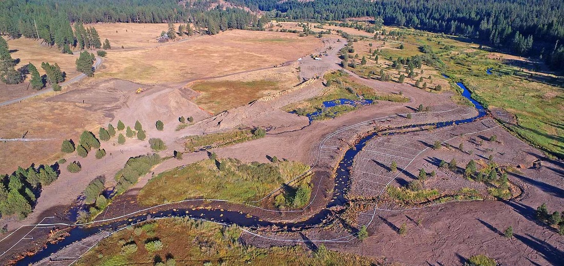
By Emily Davis Have you heard? After five years and as many project phases, the Oxbow Mine Tailings Restoration Project is finally complete! This ambitious project on the Oxbow Conservation Area sought to restore a large area of the Middle Fork John Day River severely damaged by gold dredging in the 1940s. Project leaders from the Confederated Tribes of Warm Springs worked together with partner US Bureau of Reclamation to re-meander the river, reconnect it to the floodplain, restore habitat complexity such as side channels, and plant native riparian vegetation.
See photos and read more about the project on the Warm Springs Fisheries website: http://wsfish.org/2016/12/31/oxbow-restoration-project/ If you’re local, you may also want to come out to the Middle Fork and see the project for yourself! The restored area is visible along County Road 20, but for a closer look, the Oxbow Conservation Area is open to the public. Directions and more information are here. By Emily Davis 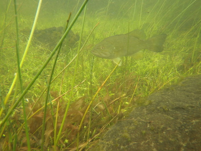 Late spring is nesting time for bass in the John Day area. Here, an adult smallmouth bass guards its nest, watching for egg predators. Photo by Erika Sutherland. If you live or work along a river in eastern Oregon, there’s a good chance that on a warm summer day you’ve cast a line into the water hoping to hook a smallmouth bass. These beautifully striped fish are plentiful in the John Day watershed, providing for a lucrative sport fishery in the lower reaches of the river where they were first stocked fifty years ago by Oregon Department of Fish and Wildlife. But their ubiquity and popularity belies a more unnerving reality: These nonnative fish are predatory, capable of consuming young salmon and steelhead. As climate change alters Western rivers, this warm-water fish is making its way into the upper reaches of the John Day—headwaters that currently serve as cold-water strongholds for wild spring Chinook salmon and summer steelhead. As bass move into critical spawning and rearing habitat for salmon in the Middle and North Forks of the John Day, each new generation of vulnerable juvenile salmonids is squarely in the path of hungry adult bass. Luckily, someone is keeping an eye on the bass. For the last ten years, researchers from the University of Washington’s School of Aquatic and Fishery Sciences have been tracking the progress of bass as they make their way up the North and Middle Fork John Day Rivers. Recently, I caught up with Erika Sutherland, a UW PhD student studying smallmouth bass in the Middle Fork, to learn more about how bass could impact the Middle Fork’s native salmon and what we can expect to see in the future. I joined Sutherland and her two field assistants on a brisk but sunny Saturday morning at a quiet riverside campground. After donning waders, we piled into her pickup truck—every crevice jammed with extra gear, snacks, or data sheets— and headed out to the first of three field sites along the river. Our mission: to capture young bass using a seine net, a large, unwieldy tangle of lines that is manipulated in the traditional, low-tech way: grab hold and sweep it through the water, then quickly lift up to trap any unwitting fish. After we captured the fish, Sutherland would weigh and measure them, then euthanize them to take back to the lab for further testing. Sutherland’s data collection goes much further than netting baby bass. Over the past three years, she has collected countless metrics to document all aspects of bass life from egg to adult—from snorkeling 80 miles of river to count bass to tagging 100 adult bass with radio tags and tracking them around the John Day watershed. While we navigated County Road 20’s winding hairpin turns, I quizzed Erika about her research and her three summers of fieldwork on the Middle Fork. What follows is our conversation. [Editor’s note: Answers have been edited for length and clarity.] ED: What made you decide to study bass here in the Middle Fork? ES: My story about becoming an ecologist is a bit strange. I spent 12 years flying F/A-18s for the Navy prior to going to graduate school. Although I absolutely loved serving my country, my childhood dream has always been to be an ecologist. When deciding which field of ecology to pursue, I found that I was most drawn to rivers and streams, both for their beauty and their complexity. When I was accepted into University of Washington, I was fortunate enough to overlap with [then-PhD student, now Dr.] Dave Lawrence who was studying smallmouth bass in the North and Middle Forks of the John Day River. I went out in the field with him and absolutely fell in love with the river and the region. This place is absolutely magical – a true treasure. I’ve now been conducting my own research here since 2014. ED: What is your favorite part about working in the MFJDR? ES: My favorite part is a tie between the people and the magnificent landscape. Everyone has been so supportive, generous and fun. I feel like I have a second family out here, which has been so important considering I spend 5 months a year out here away from my home in Seattle. And the beauty of the landscape speaks for itself. ED: Least favorite? ES: Hmmmm, in 2014 it was the rattlesnakes. I swear every day I came face to face with one. I haven’t seen as many since then, so perhaps I’ll go with cow patties on the riverbanks. It’s a bit unpleasant to be pulling yourself along a bank of river, face in the water and put your hand right in the thick of it. There’s no mistaking that squish…. ED: Besides direct consumption of young salmon, how else might smallmouth bass end up being a bad neighbor for native Chinook and steelhead? ES: I haven’t tested the effects of smallmouth bass on other fishes, but other studies have shown that smallmouth bass can compete for food and spawning grounds, crowding out other fish and indirectly affecting the reproductive success of salmon, trout and lamprey. Bass are top predators and they eat anything that fits in their mouths…..including a lot of insects, which are important for keeping water clear, providing food for other fishes and even providing food for the bird community that feed on hatching insects from the river. ED: Didn’t salmon evolve with predators like northern pikeminnow? If they have native predators already, why is it that a nonnative predator poses such a disproportionate threat? ES: As it turns out, salmon don’t display the same protective or defensive responses to smallmouth bass as they do to native predators that they co-evolved with such as the northern pikeminnow, making them more susceptible to predation by bass. [Editor’s note: Interested readers should check out Kuehne and Olden 2012 and Kuehne et al. 2012 for more information.] ED: How far up the MFJDR have bass made it, as of this summer? Especially considering the warm temperatures and low flows of summer 2015, I imagine they made some progress. ES: Smallmouth bass were resident up to the town of Galena in both 2015 and 2016. [Editor’s note: Galena is just 18 km (11 miles) downstream from the Oxbow Conservation Area, a major center of restoration activity.] There was a pretty good-sized population that were spawning at that stretch of river. This part of the river is still too cold for the bass to overwinter there, though, so the adults moved back downstream around September and it appears the young did not survive the winter. With warm summers and short winters, however, the young are likely to survive and adults are likely to continue to spread farther upstream. ED: Are there any limitations to bass expanding their range all the way up the MFJDR, and if so, what do you think is holding them back? ES: This is still a very open question, but right now it looks like a combination of warm water temperatures in July and August as well as low flows are important factors in defining the upstream edge of adult smallmouth bass distribution in the MFJDR. These factors also influence where bass can successfully reproduce. Juvenile survival depends mostly on how long the summer and winter seasons are. In short, if the upstream temperature and flow conditions change to suit bass, I predict they’ll expand into that region. ED: Based on what you have learned in your research, can you make a prediction as to how the bass invasion will proceed up the MFJDR in the next 5, 10, 20, 40, etc. years? ES: My former labmate, Dave Lawrence, modeled future bass invasion potential. He found that by 2040, bass would inhabit the entire Middle Fork and Chinook salmon would have only 4 kilometers [2.5] of suitable rearing habitat. By 2080, Chinook salmon are predicted to be completely excluded from the river. The good news is that simple restoration efforts such as providing shade to the river by planting streamside vegetation seem to highly influence these results, protecting the upper 31 kilometers [19 miles] of river from bass in the late summer. [Editor’s note: Those interested in Lawrence’s work should read his 2014 study here.] ED: It seems like you’ve collected just about every possible data point about bass, excluding scuba diving under the ice in January to see where they overwinter. What’s your next step? ES: My next step will be to use all the detailed information I have about the Middle and North Fork populations of bass to build a species distribution model that can predict the smallmouth bass invasion throughout the Columbia River Basin. ED: What does all of this mean for restoration? If bass invasion is dependent on temperature, should we be making that our first priority so bass can’t continue to gain a foothold? ES: This is obviously a tough question, and I don’t know much about river restoration. What I do know is that temperature appears to be a critical factor for keeping the Middle Fork a salmon stream, and our models show that shading the MFJDR could bring water temperatures down. I’ve seen other projects use temporary man-made shade structures to provide interim shade to streams while restoration continues and riparian plantings grow…seems like an interesting idea. After half an hour of dodging cattle and deer alike on Middle Fork Road, Erika pulled the truck into a gravel pullout, and we all piled out, carting a jumble of buckets, nets, and various measuring instruments down to the edge of the Middle Fork. Baby bass like to spend their days in the pondweed at the edge of slower-flowing, deeper water, so we’d spend the day seining pools. We waded into the waist-deep water and Erika explained how to drag the seine net toward the shore as quickly as possible: “Just grab the net and sprint with it.” Sprint? Hmm…..I looked skeptically at the heavy seine net, doubting my ability to simultaneously maintain my balance in flowing water while hefting the net with enough agility to capture any bass, which are known for their quick swimming abilities. But I was here to help, so I gamely grabbed a corner of the net and crouched into position, awaiting the signal from Erika. By day’s end, we were all soaking wet and freezing cold, with aching arms, but everyone was smiling—we’d netted dozens of bass and gotten the data we’d come for. As we drove back toward a warm meal and a fire at camp, we wondered aloud: What does the future hold for the Middle Fork’s native salmon and steelhead in the face of this invasion of the salmon-snatchers? Do restoration efforts provide hope for maintaining the Middle Fork as a salmon stronghold, and keeping the bass out? Time will tell—but thanks to Erika Sutherland’s dedicated research, we have more tools in our toolbox to help answer these questions. References:
Fritts, A. L., and T. N. Pearsons. 2004. Smallmouth bass predation on hatchery and wild salmonids in the Yakima River, Washington. Transactions of the American Fisheries Society 133:880-895. Kuehne, L. M., and J. D. Olden. 2012. Prey naivety in the behavioural responses of juvenile Chinook salmon (Oncorhynchus tshawytscha) to an invasive predator. Freshwater Biology 57:1126-1137. Kuehne, L. M., J. D. Olden, and. J. J. Duda. 2012. Costs of living for juvenile Chinook salmon (Oncorhynchus tshawytscha) in an increasingly warming and invaded world. Canadian Journal of Fisheries and Aquatic Sciences. 69:1621-1630. Lassuy D. 1995. Introduced species as a factor in extinction and endangerment of native fish species. American Fisheries Society Symposium 15:391–396. Lawrence, D.J., B. Stewart-Koster, J.D. Olden, A.S. Ruesch, C.E. Torgersen, J.J. Lawler, D.P. Butcher, and J.K. Crown. 2014. The interactive effects of climate change, riparian management, and a non-native predator on stream-rearing salmon. Ecological Applications. Power, M. E. 1990. Effects of fish in river food webs. Science. 250:811-814. Sanderson, B. L., K. A. Barnas, and A. M. W. Rub. 2009. Nonindigenous Species of the Pacific Northwest: An Overlooked Risk to Endangered Salmon? Bioscience 59:245-256. By Emily Davis 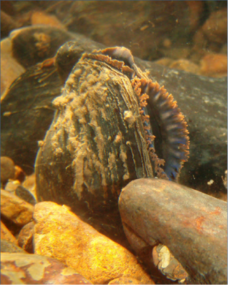 A freshwater mussel happily situated in gravel in the bottom of a stream, filtering water. Photo by Marie Fernandez, USFWS. From "Freshwater Mussels of the Pacific Northwest" If you’ve walked along the banks of the Middle Fork John Day River while fishing or boating and looked carefully, chances are you’ve seen piles of pearlescent freshwater mussel shells: remains of an otter or muskrat picnic. But few people have seen freshwater mussels alive underwater, and even fewer know anything about these mysterious creatures. Here in the Western U.S., freshwater mussels are severely under-studied, but we do know that, like their aquatic neighbors salmon and steelhead, they are experiencing a drastic decline in many places, including the Middle Fork John Day. Big river restoration projects, like the Oxbow Tailings Restoration Project on the Oxbow Conservation Area, are meant to improve conditions for native fish and mussels alike. These projects can involve drastic measures like de-watering the old channel to route water into the new channel; or using heavy equipment to re-shape an existing area by digging. This can put river dwellers, particularly those that can’t move far on their own, in a pickle. Restorationists try to save as many lives as they can by collecting and moving animals to new homes that won’t be dewatered or disturbed during the course of the project. This type of operation is called a ‘salvage.’ Fish salvages are most common, and mussels are often forgotten. The good news is that freshwater mussels are starting to get more attention from stream biologists and restorationists. As they do, efforts to save mussels before beginning big earth-moving river restoration projects are becoming more common. Why should we bother to save these un-charismatic creatures? After all, a freshwater mussel’s main skill set may appear to be impersonating a rock. In fact, mussels play a key role in stream and lake habitats across the globe. Freshwater mussels are filter-feeders: they hang out on the bottom of rivers, streams and lakes and pump water into their bodies, straining out tiny bits of food as they do so. One mussel can filter several gallons of water per day, so together, the thousands of mussels in one mile of river contribute mightily to cleaning water and clearing it of parasites and pollutants. By drawing particles out of the water and excreting them, mussels make nutrients available to other bottom-dwelling animals. Like earthworms in a garden, mussels help aerate riverbottom sediments. Mussels are also an important food source for animals like raccoons, muskrat and otters. Some species, like the Western Pearlshell—found here in the Middle Fork— can live for nearly 200 years: imagine how much water a centenarian mussel may have filtered in its lifetime! Mussels are also an important traditional food for indigenous peoples, including the Confederated Tribes of Warm Springs. As the fifth and final phase of the Oxbow Tailings Restoration Project kicked into high gear a few weeks ago, Tribal biologists prepared to conduct a freshwater mussel salvage. Over 30 volunteers from partner agencies ODFW, Malheur and Umatilla National Forests came out to assist with the effort. 95% of the volunteers had never worked with freshwater mussels before, so it was an excellent opportunity to get acquainted with these important mollusks. Crew members donned wetsuits or drysuits, snorkels, and stream boots, and climbed into the river for a crash course in mussel ID. Within just six hours, the teams of volunteers had removed over 2500 mussels from the riverbed in the salvage zone—an astounding number in less than a mile of river. Because it was too hot to continue working that day, we held the mussels overnight in a walk-in cooler, where they stayed moist and cool. The following day, another crowd of eager volunteers helped “plant” the mussels into their new home, a gravel-bottomed stretch of river just a few kilometers upstream of the restoration salvage area. With so many helping hands in the water, the impossible-seeming task of individually relocating 2500 mussels one-by-one was accomplished in just three hours. Sarah Gaulke, from the Malheur National Forest, had this to say about the experience: “It was great working together with all the partners to help out this project. I also enjoyed being able to use my muscles to help the mussels!”
When the mussel salvage was over, volunteers left the salvage zone with a new appreciation for these amazing animals; and thousands of mussels left the salvage zone with their lives. Want to learn more about the amazing freshwater mussel? Planning a restoration project and curious about how best to organize a successful mussel salvage? Visit http://www.xerces.org/western-freshwater-mussels/ to read up on these humble creatures and what you can do to help protect them. By Emily Davis 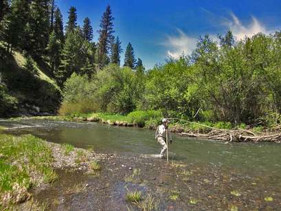 Walking the Middle Fork to count steelhead redds can be fun, especially when the sun is shining! Not pictured: many long days of chilly work in the rain and sleet. Walking the Middle Fork to count steelhead redds can be fun, especially when the sun is shining! Not pictured: many long days of chilly work in the rain and sleet. Each year, Oregon Department of Fish & Wildlife (ODFW) fish biologists brave the chilly spring waters to count steelhead nests, or “redds,” in the Middle Fork and South Fork John Day River, and their tributaries. These hard-won data are used to estimate the number of spawning steelhead in each basin, which in turn will help biologists determine how well the steelhead in each river are faring. Steelhead in the John Day River are listed as threatened under the Endangered Species Act. These fish make the 400 mile swim from the mouth of the Columbia to the Middle Fork John Day River and spawn by using their powerful tails to dig redds in the gravel where the female lays her eggs and the male fertilizes them. After covering the eggs with gravel to protect them, the steelhead head back down the river: Unlike the Chinook salmon that will spawn in these same streams later in the summer, some steelhead don’t die after spawning. They head back out to the ocean, potentially returning in following years. ODFW chose to compare the Middle Fork to the South Fork as a large-scale, long-term ecological experiment: Both rivers are important spawning and rearing habitat for the threatened Mid-Columbia Steelhead. But the Middle Fork is undergoing extensive stream habitat restoration meant to enhance steelhead and salmon populations. So, biologists can compare redd counts and other data from the two rivers to factor out influences common to the two rivers—like ocean conditions, weather, and disturbance—to analyze whether restoration is having a positive impact on the steelhead population in the Middle Fork. This year’s counts are in, and it turns out 2015 was a big year for steelhead redds! ODFW biologists estimated 524 redds in the Middle Fork John Day River IMW area during March-June 2015. This is a 180% increase from 2014 and the highest on record since surveys were started in 2008. The estimate in the South Fork John Day River was higher than 2014, but not the highest on record in that basin. Don’t get too excited just yet, though—a 180% sounds great, but higher redd counts do not necessarily translate to more spawning fish. A higher redd or fish count in just one year does not automatically mean restoration is working, either—biologists need many years of data to find a pattern they can link to a cause. Using an equation to translate redds to number of fish, ODFW biologists estimated a total of 3,784 steelhead spawners in the Middle Fork in 2015—actually lower than the 2014 estimate. Similarly, total spawner estimate for 2015 were lower than those in 2014 in the South Fork John Day River. What accounts for this paradox of more redds, but fewer fish? It is likely that the low water conditions made it easy to view redds. Low flows also mean that redds remained visible longer because high flows didn’t scour them away. The Spring of 2015 had very low streamflows, which contributed to this year’s record redd counts. What do all these redds mean for the future of the steelhead population in the Middle Fork? It is too soon to tell. More redds may mean more juvenile fish hatching, but biologists know that habitat for juvenile steelhead is very limited in the Middle Fork. More juvenile fish competing for limited resources may therefore not translate to more steelhead surviving and returning, because the already-small pie will have to be divided up into more pieces. Currently, there are more questions than answers, but ODFW is on the case. Stay tuned for an upcoming news item on juvenile steelhead abundance and survival in 2015 and how it fits in with the year’s redd count. 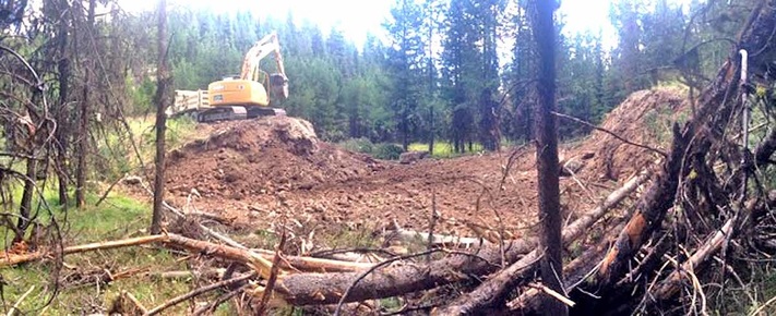 An excavator works on the newly reconstructed channel for Squaw Creek in Summer 2015. Felled trees in the foreground will be placed in the channel and on the floodplain to help trap sediment and slow erosion. An excavator works on the newly reconstructed channel for Squaw Creek in Summer 2015. Felled trees in the foreground will be placed in the channel and on the floodplain to help trap sediment and slow erosion. Squaw Creek, in the uppermost headwaters of the Middle Fork John Day River Basin, may be on the small side, but it isn’t small in terms of its potential importance to native, threatened Mid-Columbia River steelhead and other resident fish and wildlife species. Squaw Creek joins with Summit Creek 3.5 miles above Highway 7 and together these two streams become the Middle Fork John Day River (Middle Fork). Over the last century, Squaw Creek’s productive aquatic habitat slowly declined. Now, with a new restoration project, the Malheur National Forest and Oregon Department of Fish and Wildlife are working to re-intertwine the disconnected pieces of this ecosystem. Near its headwaters, Squaw Creek once meandered lazily through a 70 acre meadow, a mosaic of fens, wet sedges and dry sagebrush. When the river overtopped its banks in spring, the floodwaters created slow-flowing alcoves, side channels and backwaters ideal for young salmon and steelhead to hide, rest, and feed in. The connection of floodplain to river meant that more nutrients, insects and other food from the land traveled into the water and was available to the growing fish. Steelhead traveled hundreds of miles from the Pacific, unimpeded by weir, dam, or culvert, to spawn here. Connectivity matters: It’s how a river renews itself. Without longitudinal (upstream-downstream) connectivity, animals like steelhead—whose life cycle depends on the ability to move up and down river systems—can’t access habitat. As flows of nutrients, sediment, wood and gravel from floodplain to river are stopped or slowed through loss of lateral (side-to-side) connectivity, the river’s ability to nourish new generations of fish and wildlife becomes impoverished or lost altogether. In the case of Squaw Creek, Euroamerican settlement in the Blue Mountains brought beaver trapping, logging, grazing and fire suppression to the watershed, which created a laterally disconnected habitat that is no longer a nurturing environment for young fish to grow and thrive. More recently, road-building and log weir installation longitudinally disconnected Squaw Creek, turning it into a series of semi-isolated segments by blocking fish from getting upstream. Can connectivity be restored to this once-flourishing stream? That’s where Malheur National Forest Fisheries Biologist Kate Olsen and Hydrologist Hazel Owens come in. Olsen and Owens, in collaboration with Oregon Department of Fish and Wildlife, are leading a multi-year restoration project on Squaw Creek that aims to improve stream habitat, cool stream temperatures, and increase both lateral and longitudinal connectivity. 2015 is Year One. If all goes according to plan, a majority of the project should be finished by 2017—but its effects should last long beyond its completion date, and go much further downstream than the project site. The restoration team’s strategy to undo the disconnection and knit the isolated pieces of Squaw Creek back together is threefold. First, the team will return the artificially straightened stream channel to its historically winding, meandering flow path. A stream with more curves and meanders in it helps slow down fast-moving floodwaters, reducing erosion and cooling the water by forcing more of it to flow through gravel bars. The team will also provide places for fish to hide from predators by placing logs and root wads, such as would have been historically present, into the stream. They’ll also create places for fish to rest by making more pools. To help create shade and cool water temperatures for fish, the team is planting aspen, willow, dogwood, and alder near the reconstructed channel. Second, the team will help reconnect the stream with its floodplain. Currently, the stream runs at the bottom of a deeply carved channel, meaning the floodplain is left high and dry even at high flows, because there simply isn’t enough water to overtop the banks. To accomplish this lateral reconnection, the team is felling trees, which accomplishes two goals: First, it helps return more water to the stream, because trees use a lot of water. Historically, the trees the team is cutting would not have been present, but a century of fire suppression allowed them to invade the meadow. Secondly, the felled trees will be placed in the channel to help trap sediment and raise the streambed’s elevation. Some trees will be kept on the floodplain to slow the flow of raging floodwaters, reduce erosion, and protect riparian vegetation. Eventually, Squaw Creek will be able to overflow its banks and access the floodplain once again, creating the variety of food-rich, slow-flowing habitats so important to young fish. Finally, the team will focus on restoring longitudinal connectivity by addressing 85 fish passage barriers over the life of the project. In summer 2015 alone, fourteen log weirs throughout Squaw Creek were removed, along with a culvert that blocks both adult and juvenile steelhead passage. This barrier removal will allow fish to access more habitat where they can effectively spawn or feed and grow. The Forest Service is monitoring the local impact of the project. Meanwhile, other researchers, part of the Middle Fork Intensively Monitored Watershed collaborative, will monitor downstream of the project site to see if, and how, the Squaw Creek project impacts habitat downstream in the Middle Fork. After all, this is what connectivity is all about. What goes on upstream in the headwaters of a river can often have a profound impact on the conditions downstream. Planting shade trees to cool water temperatures for fish, for example, might not work if there is no streamside vegetation for miles upstream of the project, meaning the water flowing through your shaded project is already too hot. On the other hand, if you effectively restore enough miles of upstream habitat, your downstream restoration project might work. This is what biologists call ‘cumulative impact’—smaller impacts adding up to a whole that is bigger than the sum of its parts. This is part of why connectivity matters so much. By knitting together a headwater stream with its floodplain, and splicing its isolated segments back together with barrier removals, the Squaw Creek restoration team is restoring part of the inherent nature of this dynamic system: connectedness. Stay tuned for future updates on the Squaw Creek restoration as the project progresses! - Emily Davis
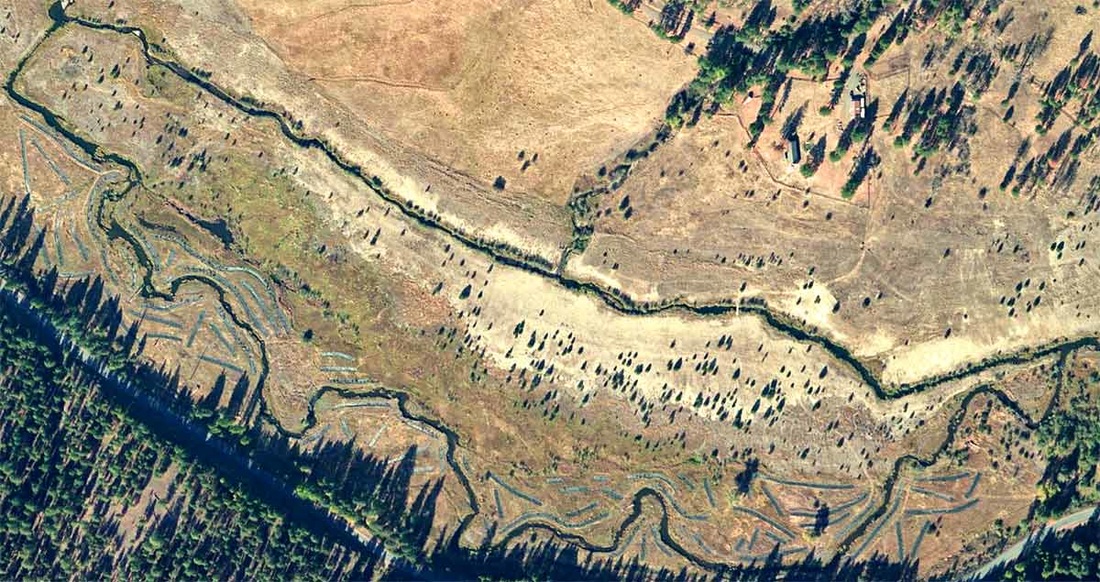
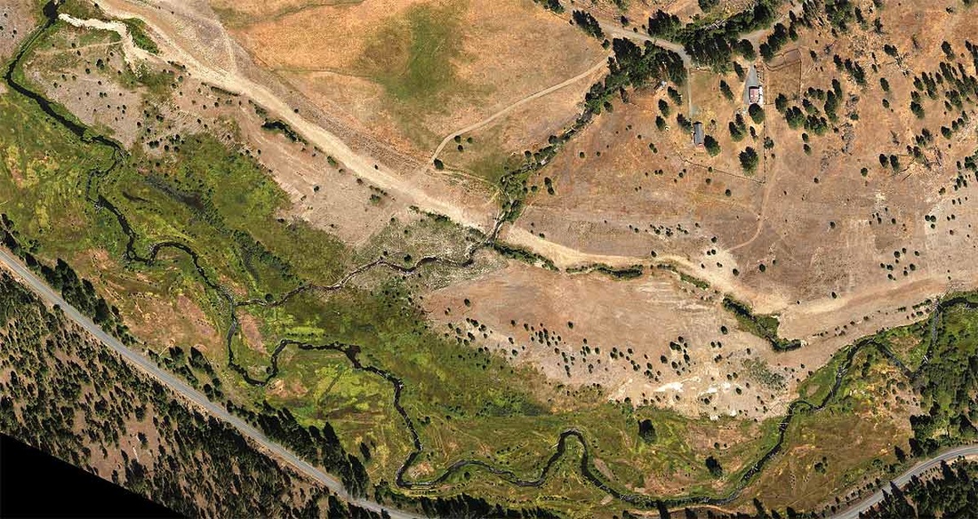
Monitoring Coordinator, Oxbow & Forrest Conservation Areas Confederated Tribes of the Warm Springs Reservation of Oregon 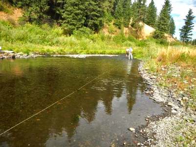 Researchers inspect a length of fiber-optic cable in the Middle Fork John Day River. To find the cable, look for the the long, white object lying on the river bottom Researchers inspect a length of fiber-optic cable in the Middle Fork John Day River. To find the cable, look for the the long, white object lying on the river bottom The Middle Fork John Day River, one of the last core strongholds for mid-Columbia steelhead and spring Chinook, is much warmer these days than it used to be, due to historic removal of shading streamside vegetation and straightening of the river channel. This can translate to lethally warm water, as biologists saw first-hand during the devastating summer fish kills of 2007, 2013 and 2015. Salmon and steelhead are cold-water fish: Warm water stresses these fish’s immune systems, putting them at higher risk of infection and disease. One urgent goal of restoration activities in the Middle Fork is to cool water temperatures to improve this crucial salmon habitat. But how do we know that our stream restoration strategies are working to cool down the river? To answer this question, the Selker Water Resources Lab at Oregon State University’s Department of Biological and Ecological Engineering has studied stream temperature in the Middle Fork since 2008. Their goal: to learn what factors, such as shade, stream channel shape, groundwater, and weather, influence stream temperature, and how we can leverage that information to get the most water-cooling bang for our buck out of our restoration projects. Their strategy? A futuristically high-tech approach involving—no joke— lasers. For many years, the only option for monitoring water temperatures was just to stick a waterproof data logger in the river at just one place, in order to record temperatures at that single place over a time period. But these point measurements don’t give us all the information, because stream temperatures also change continuously over space as a river channel changes shape, as water moves faster or slower, and as vegetation cools the water by shading. To solve this problem, the OSU scientists are looking at how temperatures change continuously along the stream length. They do this by laying fiber-optic cables along the riverbed. Fiber-optic cables, normally used for long-distance telecommunications, have now been adapted for all kinds of applications, including sensing water temperature. By using the cables—also called Distributed Temperature Sensing, or DTS— the Selker Lab can get very high-resolution temperature data. DTS works by shooting a laser down the length of the fiber optic cable. The laser’s light behaves slightly differently depending on the temperature of the water, and the researchers use this information to translate into temperature data. Starting in 2013, large-scale installations of these cables have gathered data in the Middle Fork of the John Day River, collecting temperatures over about 8 miles of river. The Selker Lab has focused much of their effort on stream sections within two major restoration project sites (Phase 2 and Phase 3*) on the Confederated Tribes of Warm Springs’ Oxbow Conservation Area. In 2012, the Phase 2 project consolidated the river channel from two channels back into its single, historic channel, while plugging the old, man-made channel. Whereas before the water ran through two shallower channels, with roughly twice the surface area, the current single channel means a deeper stream with less exposed surface area, reducing the ability of the sun to warm up the water. The lab found that within and downstream of the Phase 2 project site, temperatures swung less wildly from one extreme to the other between day and night. This means that during the make-or-break time of day when it really matters for salmon—the hottest hours, between 2 and 5 pm— the restored channel is doing its job by keeping the water cooler. Meanwhile, at night, the temperatures in the new channel cool off less dramatically than they would have in the old channels. The ability of the restored channel to buffer dramatic swings in temperature and keep the stream cooled during the day is a potential win for fish. By contrast, Oxbow’s Phase 3 project, completed in 2014, is projected to actually increase stream surface area. That’s because it took an artificially straightened channel and added bends and meanders. Re-meandering the river does a number of beneficial things: it slows down the water during high flows, decreasing bank erosion; allows the river to flood its banks and exchange sediment and nutrients with its floodplain; and creates more pools and alcoves for fish to rest and feed. In the short term, the increased stream surface area is predicted to actually warm the water slightly—at least until the thousands of newly planted willows and alders get taller and provide some shade. The team predicts that if restoration changes the river channel by making it wider, it will need taller vegetation to shade it effectively than a narrow channel would. These predictions help determine if and where planting vegetation is most effective for achieving cooler water temperatures. In the long term, the Selker team predicts that the taller and denser the riparian canopy gets, the more shaded the channel will be, and the cooler the water. But just because Phase 3 is predicted to slightly warm temperatures in the short term does not mean this restoration project won’t be successful. These results illustrate the challenging trade-offs that large-scale, comprehensive river restoration poses. Though warm temperatures are one of the most limiting factors for salmon in the Middle Fork, another obstacle is the lack of space for juvenile fish to thrive and survive so they can successfully return as adults to spawn. Even if all of the Middle Fork were shaded and cooled off, helping more adult salmon survive the summer and spawn in the fall, there still wouldn’t be enough space to support increased numbers of juvenile fish—the very problem that much of the Oxbow restoration is designed to address. What’s next for DTS in the Middle Fork? As global climate change continues to heat up our summers, DTS data is being used to “virtually” compare pre- and post-restoration stream temperatures under potential future climate scenarios, to predict which restoration efforts might work best in the future. And meanwhile, salmon and steelhead are cooling off from the hot summer sun in the restored river channels. * A multi-year, multi-phase restoration effort on the Oxbow Conservation Area has been split into five phases. Three phases are completed; Phase IV is currently underway. Before restoration (top photo), the river was split into two channels (North and South) and Granite Boulder Creek (top middle of both photos) flowed into the North channel After restoration (bottom photo), flow was redirected to the historic South channel and Granite Boulder Creek was once again able to contribute its cold water and effectively cool down the river - Emily Davis
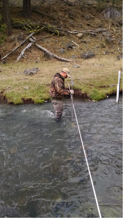
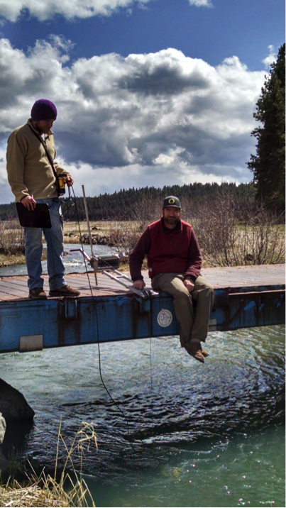
Monitoring Coordinator, Oxbow & Forrest Conservation Areas Confederated Tribes of the Warm Springs Reservation of Oregon By Emily Davis 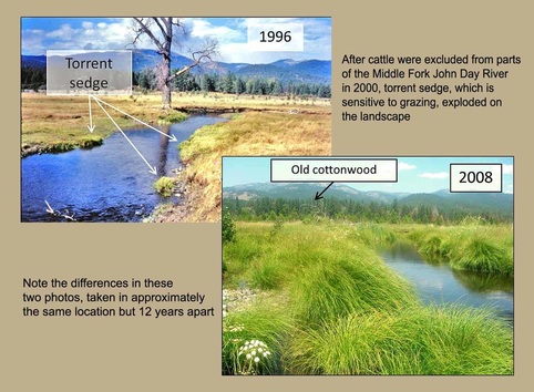 What do you think of when you hear the word ‘engineer’? For many, the term conjures an image of activity, of working hard to build or change something. An ecosystem engineer is a living thing that dramatically changes its surrounding environment, influencing habitat for many other critters along the way. Beavers are a classic example of an ecosystem engineer. Their dam-building floods valleys, transforming running streams into deep, still ponds and wetlands, often creating lush oases in the middle of otherwise arid lands. River restoration practitioners applaud beavers because they save us a lot of work. But what if a plant—a sedentary being— could be an engineer? The humble torrent sedge (Carex nudata), a water-loving plant native to many rivers in Oregon and California, may be just such an unsung hero. In the Middle Fork John Day River, the torrent sedge has been quietly changing its landscape just as much as any busy beaver, but without all the hustle and bustle and fanfare. Since the 1990s, the Middle Fork has been the focus of enormous and complex restoration efforts to repair the damage done by previous logging, gold dredging, and cattle grazing. In 2001, the Confederated Tribes of Warm Springs acquired the Forrest and Oxbow Conservation Areas on the Middle Fork, and promptly built fences to exclude cows from the river. Simply as a result of removing cattle grazing from the riverbanks, torrent sedge exploded across the landscape. And when that happened, it didn’t escape the notice of Dr. Patricia McDowell, from the University of Oregon’s Department of Geography. McDowell, a geomorphologist, had been working on the Middle Fork for awhile, and had her eye on torrent sedge the whole time. For years, she wondered about its potential role in restoration. When PhD student Matthew Goslin expressed an interest in torrent sedge, a long-awaited research project was finally able to begin. “The first time I saw torrent sedge in the Middle Fork, I just thought it was an incredibly beautiful plant, and I wanted to learn more about it,” says Goslin. “Lots of researchers focus on problems, on negative issues or what’s going wrong. I was really drawn to the idea of learning about this plant that seemed to be doing positive things [in the river].” Until recently, fluvial geomorphology—the study of rivers, their shape and how they change—focused on physical processes like the movement of water and sediment. Plants were more or less ignored as agents of change. But that line of thinking is beginning to change. These days, researchers acknowledge plants as playing a role in changing river shapes, flow, erosion and sedimentation in complex ways. Goslin’s research aims to advance this idea that the plant-river relationship is reciprocal: that plants can alter the shape of the river just as the shape of the river can influence plant communities. When it comes to standing up to the power of the river, torrent sedge is tough. The plants build small, impenetrable fortresses, called ‘tussocks,’ with their dense root systems. These root balls are so tenacious that McDowell and Goslin began imagining them as ‘organic boulders.’ These ‘organic boulders’ are immobile objects in the river that can withstand fast currents and redirect flows; but that also grow and reproduce, building islands as they do so. As a result, torrent sedge appears to be changing the shape of the river from a simple, single-thread channel to a complex multi-threaded channel, creating a rich diversity of habitat for fish and other creatures. River restoration practitioners, like those working on the Oxbow Conservation Area, increasingly think of the unassuming torrent sedge as a positive contributor to the river landscape. Torrent sedge is now being transplanted into restoration projects, but with only a vague understanding of its potential function. Understanding how exactly it may change the river is essential for using it effectively in restoration work. To do the very same channel-shaping work as this modest plant, human engineers require heavy machinery like excavators, hundreds of thousands of dollars, dozens of meetings, and detailed blueprints of how to reconfigure the river. But all the torrent sedge needs is time. And, bonus feature: It does its work for free. By Emily Davis If you live on or near the Middle Fork John Day River (Middle Fork), you know that the amount of water in the river fluctuates widely throughout the year—from the roar of spring runoff to the quieter trickle of late summer. But did you know that measuring river flow is an important piece in the puzzle of salmon restoration? High flow measurements are key to understanding how restoration actions in the Middle Fork are affecting fish habitat, so being able to keep track of flow is important. The North Fork John Day Watershed Council (NFJDWC) routinely takes river and stream flow measurements in the Middle Fork. NFJDWC staff usually take these flows during times of the year when it’s easy to wade in the river, such as the low-flow season of early fall. Because of the dangers of trying to wade the river when the water is high, the NFJDWC crew was unable to collect data during these times in the past. But why bother with taking flow measurements during high water, if we already have measurements during low water? Without these measurements year-round, we’re only seeing part of the picture of what river scientists call the ‘hydrograph’, the story of what a river does over the course of a year. It’s like putting together a quarter of a jigsaw puzzle and trying to infer what you might see on the rest of the puzzle, based on the corner you have in front of you. Now, for the first time, the NFJDWC is able to get flow measurements during dangerous high-water events, and start putting together the rest of the puzzle. Using specialized equipment, and working with partners from the Bureau of Reclamation and the Malheur National Forest, NFJDWC staff successfully measured stream discharge this winter at flows that would have almost certainly knocked someone trying to use the traditional method right off their feet. The traditional method is simple: a researcher wades across the channel with a current velocity and depth meter, taking measurements every few feet. In the Middle Fork, at twenty cfs (cubic feet per second), the river slides lazily by and the water comes up to a researcher’s ankles; at seventy cfs, it becomes difficult to stay on your feet; and at several hundred cfs even the hardiest hydrologist would avoid stepping foot in the channel. The new method follows the same principles. It takes a little more time, but is much safer at high water. Flows are measured with a sounding reel from a bridge near the usual flow measurement site. A sounding reel is a specialized cable on a winch with a crank. Weights are put on the end of the cable to keep it steady in the current; the cable can then be lowered into the water to measure depth. A current velocity meter can also be attached to the cable and used to measure velocity from the safety of the bridge. The additional high flow measurements create a more complete picture of year-round flow in the Middle Fork. By understanding the changes the river undergoes during all seasons, we can get one step closer to understanding how to improve watershed health and support thriving fish populations. North Fork John Day Watershed Council, Bureau of Reclamation, and Malheur National Forest staff
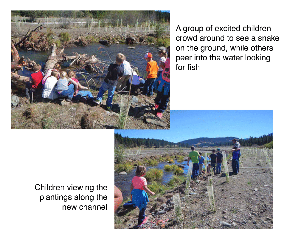
using a sounding reel to measure high flows in the Middle Fork John Day River Prairie City students learn about fish, habitat and conservation on the Middle Fork John Day River8/24/2015 By Emily Davis On September 4th 2014, a giggly and squirmy group of twenty-five 2nd and 3rd grade students from Prairie City loaded into a school bus and made the journey over Dixie Summit into the Middle Fork John Day Basin. There, Jeff Neal at Oregon Department of Fish and Wildlife and Kristen Coles at Confederated Tribes of Warm Springs led the kids on a Tour de Middle Fork, including a fish ladder at Bates State Park, a fish screen and a pool of adult Chinook salmon on the Middle Fork Forrest Conservation Area (MFFCA) and the newly completed Phase 3 Tailings Restoration Project on the Oxbow Conservation Area (OCA).
“The kids loved being outside,” said Coles. “They were really interested in the Chinook redds we saw when we walked down to the river. And of course they all wanted to play in the water and on the logs." Neal told the kids that they were seeing the project from the beginning, and they could come back in ten years when they are teenagers and see how much bigger the plantings had grown and how much more the river would be shaded. “In fifteen or twenty years, the management of the Middle Fork will be in the hands of these kids, so it’s important that we give them the chance to build a connection to this place now,” explained Emily Davis, current Monitoring Biologist for the Forrest and Oxbow Conservation Areas. “Even if they don’t understand every detail of the science or the restoration project, we can help nurture their curiosity by letting them explore.” |
IMW News Updates
Archives
September 2022
Categories |
 RSS Feed
