 The Oregon Department of Fish & Wildlife (ODFW) is monitoring fish population metrics for wild summer steelhead and wild spring Chinook salmon to evaluate population level fish responses to restoration activities. As part of this monitoring juvenile steelhead and spring Chinook salmon are tagged using passive integrated transponder (PIT) tags at various locations throughout the Middle Fork John Day Intensively Monitored Watershed (MFJD IMW). Among other applications, PIT tag detections are used in the MFJD IMW to estimate juvenile survival and productivity, and to detect adult returns (from fish that were tagged as juveniles). PIT-tagged fish can be detected in the MFJD at an array of antennas located near the mouth of Mosquito Creek.
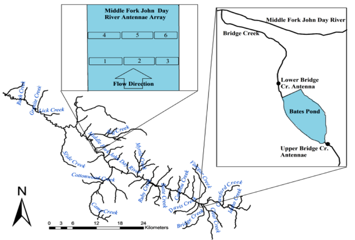
This winter, ODFW brought the Middle Fork PIT-tag antennae array on-line through PTAGIS, a regional data storage/sharing system for PIT-tag associated data in the Columbia River Basin. By querying the PTAGIS website (http://www.ptagis.org/home) IMW investigators, other PIT-tagging programs in the Columbia River Basin, and interested public can view all detections at the Middle Fork PIT-tag array, referenced as detection site MJ1. Eleven adult steelhead and 28 adult spring Chinook were detected at the Middle Fork array during the 2013 spawning season. The figure below is a map showing the location and arrangement of antenna at the Middle Fork John Day Array, as well as the location of two more antenna located in Bates State Park.
0 Comments
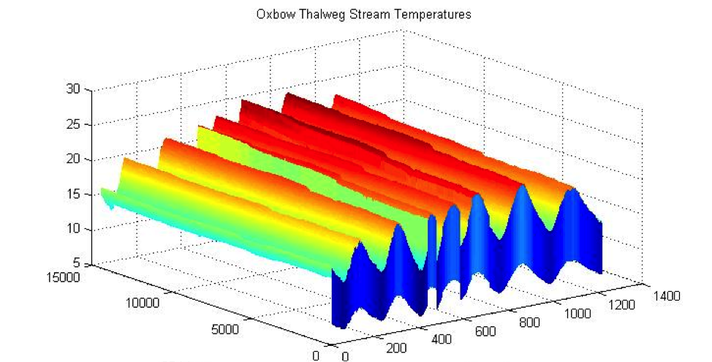 Oregon State University professor and IMW investigator, John Selker, and his students are using state-of-the-art temperature monitoring techniques on restoration properties in the Middle Fork John Day River. From August 1-8, 2013, a section of river on the Warm Springs Tribes’ Oxbow Conservation Area was monitored using a large-scale DTS (distributed temperature sensing) installation. The DTS installation consisted of fiber optic cables placed in the thalweg (deepest part of the riverbed) through which high-resolution temperature data was recorded at precise temporal and spatial scales.
Preliminary results from DTS temperature monitoring on the Oxbow Conservation Area reveal an observable sustained drop in stream temperature downstream of the Granite Boulder Creek redirection and stream channel reconstruction restoration area. This temperature drop was apparent throughout the day, although it was most pronounced during peak midday stream temperatures The following figure shows the change in watertemperature over time and distance for a section of the Middle Fork John Day River on the Oxbow Conservation Area. |
IMW News Updates
Archives
September 2022
Categories |
 RSS Feed