|
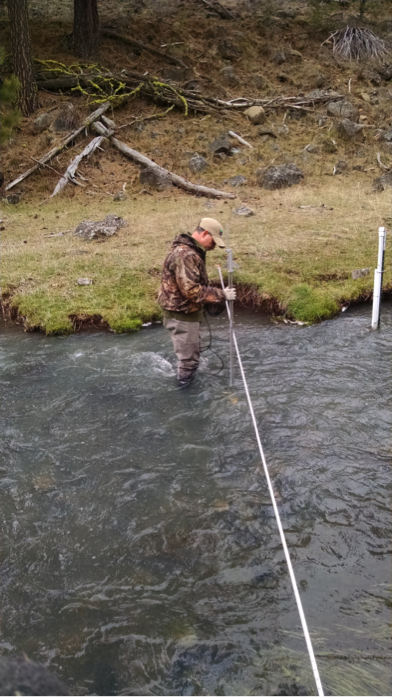
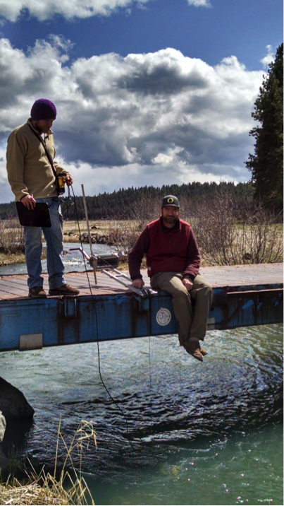
By Emily Davis If you live on or near the Middle Fork John Day River (Middle Fork), you know that the amount of water in the river fluctuates widely throughout the year—from the roar of spring runoff to the quieter trickle of late summer. But did you know that measuring river flow is an important piece in the puzzle of salmon restoration? High flow measurements are key to understanding how restoration actions in the Middle Fork are affecting fish habitat, so being able to keep track of flow is important. The North Fork John Day Watershed Council (NFJDWC) routinely takes river and stream flow measurements in the Middle Fork. NFJDWC staff usually take these flows during times of the year when it’s easy to wade in the river, such as the low-flow season of early fall. Because of the dangers of trying to wade the river when the water is high, the NFJDWC crew was unable to collect data during these times in the past. But why bother with taking flow measurements during high water, if we already have measurements during low water? Without these measurements year-round, we’re only seeing part of the picture of what river scientists call the ‘hydrograph’, the story of what a river does over the course of a year. It’s like putting together a quarter of a jigsaw puzzle and trying to infer what you might see on the rest of the puzzle, based on the corner you have in front of you. Now, for the first time, the NFJDWC is able to get flow measurements during dangerous high-water events, and start putting together the rest of the puzzle. Using specialized equipment, and working with partners from the Bureau of Reclamation and the Malheur National Forest, NFJDWC staff successfully measured stream discharge this winter at flows that would have almost certainly knocked someone trying to use the traditional method right off their feet. The traditional method is simple: a researcher wades across the channel with a current velocity and depth meter, taking measurements every few feet. In the Middle Fork, at twenty cfs (cubic feet per second), the river slides lazily by and the water comes up to a researcher’s ankles; at seventy cfs, it becomes difficult to stay on your feet; and at several hundred cfs even the hardiest hydrologist would avoid stepping foot in the channel. The new method follows the same principles. It takes a little more time, but is much safer at high water. Flows are measured with a sounding reel from a bridge near the usual flow measurement site. A sounding reel is a specialized cable on a winch with a crank. Weights are put on the end of the cable to keep it steady in the current; the cable can then be lowered into the water to measure depth. A current velocity meter can also be attached to the cable and used to measure velocity from the safety of the bridge. The additional high flow measurements create a more complete picture of year-round flow in the Middle Fork. By understanding the changes the river undergoes during all seasons, we can get one step closer to understanding how to improve watershed health and support thriving fish populations.
North Fork John Day Watershed Council, Bureau of Reclamation, and Malheur National Forest staff
using a sounding reel to measure high flows in the Middle Fork John Day River
0 Comments
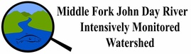
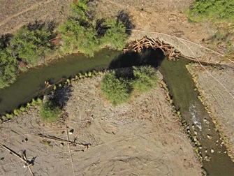
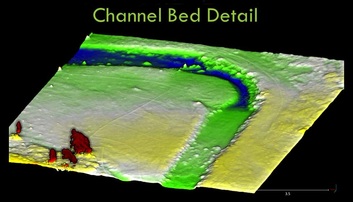
Prairie City students learn about fish, habitat and conservation on the Middle Fork John Day River8/24/2015 By Emily Davis On September 4th 2014, a giggly and squirmy group of twenty-five 2nd and 3rd grade students from Prairie City loaded into a school bus and made the journey over Dixie Summit into the Middle Fork John Day Basin. There, Jeff Neal at Oregon Department of Fish and Wildlife and Kristen Coles at Confederated Tribes of Warm Springs led the kids on a Tour de Middle Fork, including a fish ladder at Bates State Park, a fish screen and a pool of adult Chinook salmon on the Middle Fork Forrest Conservation Area (MFFCA) and the newly completed Phase 3 Tailings Restoration Project on the Oxbow Conservation Area (OCA). “The kids loved being outside,” said Coles. “They were really interested in the Chinook redds we saw when we walked down to the river. And of course they all wanted to play in the water and on the logs." Neal told the kids that they were seeing the project from the beginning, and they could come back in ten years when they are teenagers and see how much bigger the plantings had grown and how much more the river would be shaded. “In fifteen or twenty years, the management of the Middle Fork will be in the hands of these kids, so it’s important that we give them the chance to build a connection to this place now,” explained Emily Davis, current Monitoring Biologist for the Forrest and Oxbow Conservation Areas. “Even if they don’t understand every detail of the science or the restoration project, we can help nurture their curiosity by letting them explore.” 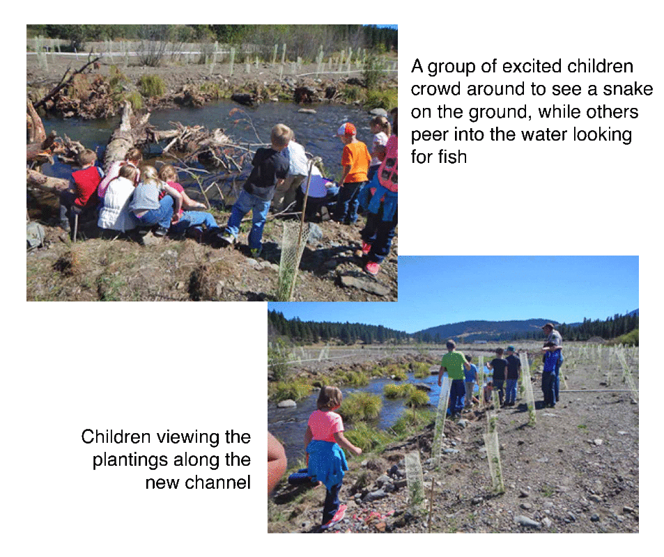 Second and third graders from Prairie City, OR visiting the newly completed Phase 3 Tailings Restoration Project on the Oxbow Conservation Area By Emily Davis 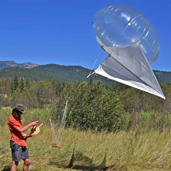 University of Oregon graduate student deploying heli-kite with digital camera attached University of Oregon graduate student deploying heli-kite with digital camera attached Aug 24, 2015 Researchers use low-cost techniques to produce high-resolution images of new river channel construction in the Oxbow Conservation Area The Oxbow Conservation Area (OCA) on the Middle Fork John Day River (Middle Fork) has been the site of some ambitious and impressive river channel restoration projects in the last few years. The big question on everyone’s mind is: How can we monitor our restoration projects to see what kind of change takes place over time, and hopefully connect that to changes we see in fish populations? And how can we do it effectively, without expending too much money or time? Researchers at the University of Oregon think they may have the answer to this riddle. Using a creative approach and a unique assortment of tools, scientists from the McDowell Geomorphology Lab are using a technique that, in just an afternoon, can collect more data than an army of students could collect in a whole summer. Decades of gold dredging and other channel straightening activities made this reach of the Middle Fork an unfriendly place for fish. The channel reconstruction project on the OCA took a straight, relatively uniform stretch of river and turned it into a more natural meandering channel with more deep pools. The hope of the channel reconstruction project was to provide the nooks, crannies, and diversity of habitat types that fish—especially juvenile salmon— need to rest, feed, and hide from predators. So how has the river channel changed since the project was implemented? To find out, UO graduate students working in the McDowell Lab attached an ordinary digital camera to a heli-kite flown over a portion of the reconstructed channel during the course of an afternoon. A heli-kite is a deceptively simple device: just a small helium balloon with two ropes attached and a place to attach the digital camera. It can be easily operated by two people. With one person standing on either side of the river channel, each holding a rope attached to the heli-kite, and the helium balloon holding the camera overhead in the middle, the crew then walks down the stretch of river they are interested in analyzing. As the camera passes overhead of the channel, it snaps a multitude of overlapping images, about one every second. The images are later analyzed using special computer software that matches up the overlapping photos, creating a digital image of the structure of the riverbed. In essence, the software creates a 3-D ‘tour’ of the channel shape using the photos. “It’s analogous to what you might see if you went to a realtor’s website and got a 3-D tour of the inside of a house for sale,” says project leader Dr. Pat McDowell. “Just way more precise, of course.” What can an interested researcher do with this 3-D tour of the riverbed? For one, it allows restoration practitioners to more easily track how their projects are changing the physical landscape over time. Such monitoring has historically relied on very time-intensive field methods, requiring lots of personnel and money to complete. Initial results from 2014 (photo 3) show increased channel bed complexityextensive restoration project. More channel bed complexity could mean improved aquatic habitat for fish and other critters in the Middle Fork. The heli-kite method is unique and simple—and it means monitoring the success trajectory of restoration at the Oxbow Conservation Area and elsewhere on the Middle Fork could get a whole lot easier in the future.
|
IMW News Updates
Archives
September 2022
Categories |
 RSS Feed