|
By Emily Davis 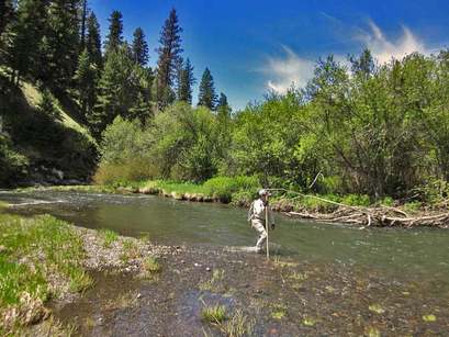 Walking the Middle Fork to count steelhead redds can be fun, especially when the sun is shining! Not pictured: many long days of chilly work in the rain and sleet. Walking the Middle Fork to count steelhead redds can be fun, especially when the sun is shining! Not pictured: many long days of chilly work in the rain and sleet. Each year, Oregon Department of Fish & Wildlife (ODFW) fish biologists brave the chilly spring waters to count steelhead nests, or “redds,” in the Middle Fork and South Fork John Day River, and their tributaries. These hard-won data are used to estimate the number of spawning steelhead in each basin, which in turn will help biologists determine how well the steelhead in each river are faring. Steelhead in the John Day River are listed as threatened under the Endangered Species Act.
These fish make the 400 mile swim from the mouth of the Columbia to the Middle Fork John Day River and spawn by using their powerful tails to dig redds in the gravel where the female lays her eggs and the male fertilizes them. After covering the eggs with gravel to protect them, the steelhead head back down the river: Unlike the Chinook salmon that will spawn in these same streams later in the summer, some steelhead don’t die after spawning. They head back out to the ocean, potentially returning in following years. ODFW chose to compare the Middle Fork to the South Fork as a large-scale, long-term ecological experiment: Both rivers are important spawning and rearing habitat for the threatened Mid-Columbia Steelhead. But the Middle Fork is undergoing extensive stream habitat restoration meant to enhance steelhead and salmon populations. So, biologists can compare redd counts and other data from the two rivers to factor out influences common to the two rivers—like ocean conditions, weather, and disturbance—to analyze whether restoration is having a positive impact on the steelhead population in the Middle Fork. This year’s counts are in, and it turns out 2015 was a big year for steelhead redds! ODFW biologists estimated 524 redds in the Middle Fork John Day River IMW area during March-June 2015. This is a 180% increase from 2014 and the highest on record since surveys were started in 2008. The estimate in the South Fork John Day River was higher than 2014, but not the highest on record in that basin. Don’t get too excited just yet, though—a 180% sounds great, but higher redd counts do not necessarily translate to more spawning fish. A higher redd or fish count in just one year does not automatically mean restoration is working, either—biologists need many years of data to find a pattern they can link to a cause. Using an equation to translate redds to number of fish, ODFW biologists estimated a total of 3,784 steelhead spawners in the Middle Fork in 2015—actually lower than the 2014 estimate. Similarly, total spawner estimate for 2015 were lower than those in 2014 in the South Fork John Day River. What accounts for this paradox of more redds, but fewer fish? It is likely that the low water conditions made it easy to view redds. Low flows also mean that redds remained visible longer because high flows didn’t scour them away. The Spring of 2015 had very low streamflows, which contributed to this year’s record redd counts. What do all these redds mean for the future of the steelhead population in the Middle Fork? It is too soon to tell. More redds may mean more juvenile fish hatching, but biologists know that habitat for juvenile steelhead is very limited in the Middle Fork. More juvenile fish competing for limited resources may therefore not translate to more steelhead surviving and returning, because the already-small pie will have to be divided up into more pieces. Currently, there are more questions than answers, but ODFW is on the case. Stay tuned for an upcoming news item on juvenile steelhead abundance and survival in 2015 and how it fits in with the year’s redd count.
1 Comment
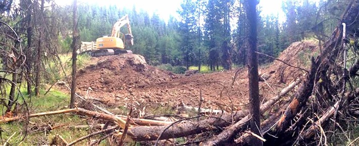 An excavator works on the newly reconstructed channel for Squaw Creek in Summer 2015. Felled trees in the foreground will be placed in the channel and on the floodplain to help trap sediment and slow erosion. An excavator works on the newly reconstructed channel for Squaw Creek in Summer 2015. Felled trees in the foreground will be placed in the channel and on the floodplain to help trap sediment and slow erosion. Squaw Creek, in the uppermost headwaters of the Middle Fork John Day River Basin, may be on the small side, but it isn’t small in terms of its potential importance to native, threatened Mid-Columbia River steelhead and other resident fish and wildlife species. Squaw Creek joins with Summit Creek 3.5 miles above Highway 7 and together these two streams become the Middle Fork John Day River (Middle Fork). Over the last century, Squaw Creek’s productive aquatic habitat slowly declined. Now, with a new restoration project, the Malheur National Forest and Oregon Department of Fish and Wildlife are working to re-intertwine the disconnected pieces of this ecosystem. Near its headwaters, Squaw Creek once meandered lazily through a 70 acre meadow, a mosaic of fens, wet sedges and dry sagebrush. When the river overtopped its banks in spring, the floodwaters created slow-flowing alcoves, side channels and backwaters ideal for young salmon and steelhead to hide, rest, and feed in. The connection of floodplain to river meant that more nutrients, insects and other food from the land traveled into the water and was available to the growing fish. Steelhead traveled hundreds of miles from the Pacific, unimpeded by weir, dam, or culvert, to spawn here. Connectivity matters: It’s how a river renews itself. Without longitudinal (upstream-downstream) connectivity, animals like steelhead—whose life cycle depends on the ability to move up and down river systems—can’t access habitat. As flows of nutrients, sediment, wood and gravel from floodplain to river are stopped or slowed through loss of lateral (side-to-side) connectivity, the river’s ability to nourish new generations of fish and wildlife becomes impoverished or lost altogether. In the case of Squaw Creek, Euroamerican settlement in the Blue Mountains brought beaver trapping, logging, grazing and fire suppression to the watershed, which created a laterally disconnected habitat that is no longer a nurturing environment for young fish to grow and thrive. More recently, road-building and log weir installation longitudinally disconnected Squaw Creek, turning it into a series of semi-isolated segments by blocking fish from getting upstream. Can connectivity be restored to this once-flourishing stream? That’s where Malheur National Forest Fisheries Biologist Kate Olsen and Hydrologist Hazel Owens come in. Olsen and Owens, in collaboration with Oregon Department of Fish and Wildlife, are leading a multi-year restoration project on Squaw Creek that aims to improve stream habitat, cool stream temperatures, and increase both lateral and longitudinal connectivity. 2015 is Year One. If all goes according to plan, a majority of the project should be finished by 2017—but its effects should last long beyond its completion date, and go much further downstream than the project site. The restoration team’s strategy to undo the disconnection and knit the isolated pieces of Squaw Creek back together is threefold. First, the team will return the artificially straightened stream channel to its historically winding, meandering flow path. A stream with more curves and meanders in it helps slow down fast-moving floodwaters, reducing erosion and cooling the water by forcing more of it to flow through gravel bars. The team will also provide places for fish to hide from predators by placing logs and root wads, such as would have been historically present, into the stream. They’ll also create places for fish to rest by making more pools. To help create shade and cool water temperatures for fish, the team is planting aspen, willow, dogwood, and alder near the reconstructed channel. Second, the team will help reconnect the stream with its floodplain. Currently, the stream runs at the bottom of a deeply carved channel, meaning the floodplain is left high and dry even at high flows, because there simply isn’t enough water to overtop the banks. To accomplish this lateral reconnection, the team is felling trees, which accomplishes two goals: First, it helps return more water to the stream, because trees use a lot of water. Historically, the trees the team is cutting would not have been present, but a century of fire suppression allowed them to invade the meadow. Secondly, the felled trees will be placed in the channel to help trap sediment and raise the streambed’s elevation. Some trees will be kept on the floodplain to slow the flow of raging floodwaters, reduce erosion, and protect riparian vegetation. Eventually, Squaw Creek will be able to overflow its banks and access the floodplain once again, creating the variety of food-rich, slow-flowing habitats so important to young fish. Finally, the team will focus on restoring longitudinal connectivity by addressing 85 fish passage barriers over the life of the project. In summer 2015 alone, fourteen log weirs throughout Squaw Creek were removed, along with a culvert that blocks both adult and juvenile steelhead passage. This barrier removal will allow fish to access more habitat where they can effectively spawn or feed and grow. The Forest Service is monitoring the local impact of the project. Meanwhile, other researchers, part of the Middle Fork Intensively Monitored Watershed collaborative, will monitor downstream of the project site to see if, and how, the Squaw Creek project impacts habitat downstream in the Middle Fork. After all, this is what connectivity is all about. What goes on upstream in the headwaters of a river can often have a profound impact on the conditions downstream. Planting shade trees to cool water temperatures for fish, for example, might not work if there is no streamside vegetation for miles upstream of the project, meaning the water flowing through your shaded project is already too hot. On the other hand, if you effectively restore enough miles of upstream habitat, your downstream restoration project might work. This is what biologists call ‘cumulative impact’—smaller impacts adding up to a whole that is bigger than the sum of its parts. This is part of why connectivity matters so much. By knitting together a headwater stream with its floodplain, and splicing its isolated segments back together with barrier removals, the Squaw Creek restoration team is restoring part of the inherent nature of this dynamic system: connectedness. Stay tuned for future updates on the Squaw Creek restoration as the project progresses! - Emily Davis
Monitoring Coordinator, Oxbow & Forrest Conservation Areas Confederated Tribes of the Warm Springs Reservation of Oregon 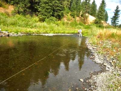 Researchers inspect a length of fiber-optic cable in the Middle Fork John Day River. To find the cable, look for the the long, white object lying on the river bottom Researchers inspect a length of fiber-optic cable in the Middle Fork John Day River. To find the cable, look for the the long, white object lying on the river bottom The Middle Fork John Day River, one of the last core strongholds for mid-Columbia steelhead and spring Chinook, is much warmer these days than it used to be, due to historic removal of shading streamside vegetation and straightening of the river channel. This can translate to lethally warm water, as biologists saw first-hand during the devastating summer fish kills of 2007, 2013 and 2015. Salmon and steelhead are cold-water fish: Warm water stresses these fish’s immune systems, putting them at higher risk of infection and disease. One urgent goal of restoration activities in the Middle Fork is to cool water temperatures to improve this crucial salmon habitat. But how do we know that our stream restoration strategies are working to cool down the river? To answer this question, the Selker Water Resources Lab at Oregon State University’s Department of Biological and Ecological Engineering has studied stream temperature in the Middle Fork since 2008. Their goal: to learn what factors, such as shade, stream channel shape, groundwater, and weather, influence stream temperature, and how we can leverage that information to get the most water-cooling bang for our buck out of our restoration projects. Their strategy? A futuristically high-tech approach involving—no joke— lasers. For many years, the only option for monitoring water temperatures was just to stick a waterproof data logger in the river at just one place, in order to record temperatures at that single place over a time period. But these point measurements don’t give us all the information, because stream temperatures also change continuously over space as a river channel changes shape, as water moves faster or slower, and as vegetation cools the water by shading. To solve this problem, the OSU scientists are looking at how temperatures change continuously along the stream length. They do this by laying fiber-optic cables along the riverbed. Fiber-optic cables, normally used for long-distance telecommunications, have now been adapted for all kinds of applications, including sensing water temperature. By using the cables—also called Distributed Temperature Sensing, or DTS— the Selker Lab can get very high-resolution temperature data. DTS works by shooting a laser down the length of the fiber optic cable. The laser’s light behaves slightly differently depending on the temperature of the water, and the researchers use this information to translate into temperature data. Starting in 2013, large-scale installations of these cables have gathered data in the Middle Fork of the John Day River, collecting temperatures over about 8 miles of river. The Selker Lab has focused much of their effort on stream sections within two major restoration project sites (Phase 2 and Phase 3*) on the Confederated Tribes of Warm Springs’ Oxbow Conservation Area. In 2012, the Phase 2 project consolidated the river channel from two channels back into its single, historic channel, while plugging the old, man-made channel. Whereas before the water ran through two shallower channels, with roughly twice the surface area, the current single channel means a deeper stream with less exposed surface area, reducing the ability of the sun to warm up the water. The lab found that within and downstream of the Phase 2 project site, temperatures swung less wildly from one extreme to the other between day and night. This means that during the make-or-break time of day when it really matters for salmon—the hottest hours, between 2 and 5 pm— the restored channel is doing its job by keeping the water cooler. Meanwhile, at night, the temperatures in the new channel cool off less dramatically than they would have in the old channels. The ability of the restored channel to buffer dramatic swings in temperature and keep the stream cooled during the day is a potential win for fish. By contrast, Oxbow’s Phase 3 project, completed in 2014, is projected to actually increase stream surface area. That’s because it took an artificially straightened channel and added bends and meanders. Re-meandering the river does a number of beneficial things: it slows down the water during high flows, decreasing bank erosion; allows the river to flood its banks and exchange sediment and nutrients with its floodplain; and creates more pools and alcoves for fish to rest and feed. In the short term, the increased stream surface area is predicted to actually warm the water slightly—at least until the thousands of newly planted willows and alders get taller and provide some shade. The team predicts that if restoration changes the river channel by making it wider, it will need taller vegetation to shade it effectively than a narrow channel would. These predictions help determine if and where planting vegetation is most effective for achieving cooler water temperatures. In the long term, the Selker team predicts that the taller and denser the riparian canopy gets, the more shaded the channel will be, and the cooler the water. But just because Phase 3 is predicted to slightly warm temperatures in the short term does not mean this restoration project won’t be successful. These results illustrate the challenging trade-offs that large-scale, comprehensive river restoration poses. Though warm temperatures are one of the most limiting factors for salmon in the Middle Fork, another obstacle is the lack of space for juvenile fish to thrive and survive so they can successfully return as adults to spawn. Even if all of the Middle Fork were shaded and cooled off, helping more adult salmon survive the summer and spawn in the fall, there still wouldn’t be enough space to support increased numbers of juvenile fish—the very problem that much of the Oxbow restoration is designed to address. What’s next for DTS in the Middle Fork? As global climate change continues to heat up our summers, DTS data is being used to “virtually” compare pre- and post-restoration stream temperatures under potential future climate scenarios, to predict which restoration efforts might work best in the future. And meanwhile, salmon and steelhead are cooling off from the hot summer sun in the restored river channels. * A multi-year, multi-phase restoration effort on the Oxbow Conservation Area has been split into five phases. Three phases are completed; Phase IV is currently underway. 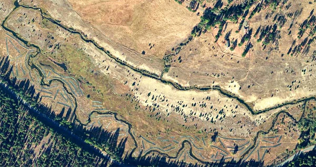 Before restoration (top photo), the river was split into two channels (North and South) and Granite Boulder Creek (top middle of both photos) flowed into the North channel After restoration (bottom photo), flow was redirected to the historic South channel and Granite Boulder Creek was once again able to contribute its cold water and effectively cool down the river 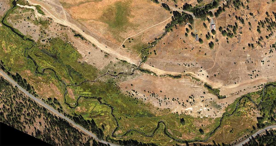 - Emily Davis
Monitoring Coordinator, Oxbow & Forrest Conservation Areas Confederated Tribes of the Warm Springs Reservation of Oregon |
IMW News Updates
Archives
September 2022
Categories |
 RSS Feed